For centuries, European maps showed you islands that weren’t there.
Not undiscovered islands.
Islands that did not exist.
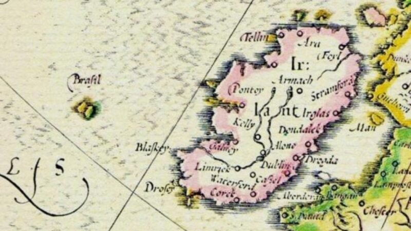
One of these was Hy-Brasil, said to be located in the Atlantic west of Ireland.
Maps began showing Hy-Brasil in the 14th century and continue showing this “island” for several hundred years. Sailors claimed to see it through mist and fog and said the island appeared once every seven years. Fascinating history for sure. The name Hy-Brasil could either have been derived from a type of dye or an Irish clan. Take your pick there!
Explorers then did what explorers do and went looking and found nothing but ocean.
Eventually you couldn’t find Hy-Brasil on maps from reputable map-makers. Hy-Brasil became a member of the phantom geography club. Islands and other geographic features in the phantom geography club were created by bad or mistaken sightings, bad reports, navigational errors or sometimes conjured from an over-active sailor’s imagination.
And cartographers, the mapmakers who drew the known world and defined what their era knew of that world, endlessly reproduced these mirages. You can easily find them on many maps created by a multitude of cartographers.
If a phantom island appeared on a map, most later mapmakers simply reproduced that nonexistent bit of land. A mistake was given a coastline, a name, coordinates – the whole geographics works. In their defense there was no Internet and they certainly couldn’t fly a drone up to verify.
In that way the map became the territory. The map was the only real thing about the place.
Search for these old maps in various archives. You’ll see bits and pieces of worlds that never existed but yet you’ll see them fully mapped.
In a strange intersection of geography and folklore, phantoms were reality.